
Stanislawow (Ivano-Frankivsk)
שם באוקראינית:
Ivano-Frankivsk [Івано-Франківськ], Stanislav [Станiслав]
שם בפולנית:
Stanisławów
שם בגרמנית:
Stanislau
שם בעברית:
איוונו-פרנקיבסק, סטניסלבוב
שם ביידיש:
Stanislev [סטאניסלעוו]
אזור היסטורי-תרבותי:
Eastern Galicia - Prikarpattia
היסטוריה מנהלית:
| Years | State | Province | District |
| Till 1772 | Polish-Lithuanian Commonwealth: Kingdom of Poland |
Rus Voivodship (Województwo ruskie) |
|
| 1772-1867 | "Hapsburg Empire", since 1804 - Austrian Empire | Kingdom of Galicia and Lodomeria (Königreich Galizien und Lodomerien) | |
| 1867-1914 | Austro-Hungarian Monarchy | Kingdom of Galicia and Lodomeria (Königreich Galizien und Lodomerien) | Stanislau Gebiet/powiat |
| 1914-1915 | Under Russian occupation | General-Government Galitsiia | |
| 1915-1918 | Austro-Hungarian Monarchy | Kingdom of Galicia and Lodomeria (Königreich Galizien und Lodomerien) | Stanislau Gebiet/powiat |
| 1918 - May 1919 | West-Ukrainian People's Republic | ||
| May 1919 - September 1939 | Republic of Poland | Stanislawów wojewódstwo | Stanislawów poniat |
| September 1939 - June 1941 | USSR: Ukrainian Soviet Socialist Republic | Stanislav oblast' | |
| June 1941 - July 1944 | Under German occupation: General Government (Das Generalgouvernement für die besetzten polnischen Gebiete | Distrikt Galizien | |
| 1944-91 | USSR: Ukrainian Soviet Socialist Republic | Stanislavov (Stanislaviv) oblast'; since 1962 renamed Ivano-Frankovsk (Ivano-Frankivs'k) oblast' | |
| Since 1991 | Republic of Ukraine | Ivano-Frankivs'k oblast' |
נתוני אוכלוסייה:
| Year | Total | Jews | Percentage of Jews |
| 1792 | 5,432 | 2,237 | 41.1% |
| 1847 | 10,866 | 5,958 | 54.8% |
| 1880 | 18,626 | 10,028 | 53.8% |
| 1910 | 33,280 | 15,253 | 45.8% |
| 1921 | 28,204 | 15,860 | 56.2% |
| 1931 | 72,350 | 24,823 | 34.3% |
| 2008 |
222,000 |
~300 |
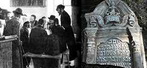
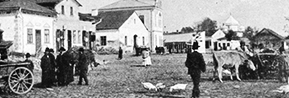
Ivano-Frankivsk is a historic city located in southwestern Ukraine (453 km from Kiev). It is the administrative center of the Ivano-Frankivsk Oblast (province) and its largest city. Prior to 1962, the city was known as Stanislawów. There are two rivers in the city: Bistritsa Nadvirnianska and Bistritsa Solotvinska. While the old synagogue and old Jewish cemetery were destroyed, there still exist the Temple (now the functioning synagogue), two other synagogue buildings and the new Jewish cemetery.
The photographs made by Dr. Vladimir Levin in April and August 2009 see at the Gallery section.
See historical map of the city (1939) here
פריטים רלוונטיים לקהילה
| כותרת | סוג הפריט | שנה |
|---|---|---|
| A Teacher in Solotvin | מאגר שמות | |
| Aisman | מאגר שמות | עד 1943 |
| Buvenfelts | מאגר שמות | עד 1943 |
| Gittel Mosberg | מאגר שמות | 1845 עד 1939 |
| Malka Grossbach | מאגר שמות | 1844 עד 1939 |
| Mechel Feidmorn | מאגר שמות | עד 1939 |
| Moses Bergman | מאגר שמות | 1873 עד 1939 |
| Sara Schwarz | מאגר שמות | עד 1939 |
| Shmil | מאגר שמות | עד 1943 |
| Shmyrko | מאגר שמות | 1892 עד 1943 |